


The spatial distribution of heavy metals in soils and industrial wastes in Angren (Uzbekistan)
table of content
The spatial distribution of heavy metals in soils and industrial wastes in Angren (Uzbekistan) by use of remote sensing data as basic information for monitoring
Funding: DAAD (German Academic Exchange Service)
Duration: 01.09.2016 31.12.2017
Project Team: Prof. Cornelia Gläßer, Prof. N. Shukurov, PhD student S. Rakhmonkulova
Partners: Uzbekistan Academy of Sciences, Institute of Geology and Geophysics, Lab. Geochemistry and Geotechnologies
project description
motivation
Coal plays an important role in the energy consumption of many countries, although its mining, processing, combustion, and post combustion waste products may cause environmental and human health problems. The generation of electricity by thermal conversion of coal results in significant volumes of solid waste. Most of these materials are disposed in surface impoundments near coal-fired power plants. The concentrations of volatile heavy metals and radionuclides in the ash produced by combustion of coal are significantly higher than those in the raw coal.
Once soil is polluted, metals can be transferred from soil to other environmental media, such as underground water or crops, and pose a threat to human health because of inhalation or ingestion through the water supply and food chain. Previous studies showed that surface- and groundwater in this area, as well as soil and vegetation are highly contaminated with heavy metals.
The study site is located in one of the largest coal-mining regions and power-production centers in Uzbekistan. The climate is continental, with a maximal temperature of 40°C in summer and -25°C in winter. The coal-ash landfills are located on the upper side of the Akhangaran river valley, near the city of Angren where the coal-burning power plant (productive capacity 484 MW) is one of the major sources of air and soil pollution in this area. The electrical power station is operated on brown coal from the nearby Angren coal mine, producing 3045 % of its ash waste. During the last 58 years of operation 13m tons of coal combustion wastes were generated and disposed in 3 landfills of 203 acres.
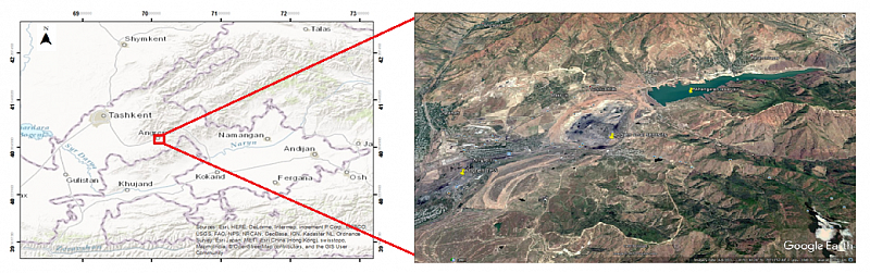
map of the study area © S. Rakhmonkulova, 2017
The main objectives are:
- Spectral library in the range of 400 to 2500 nm for ashes and sediments
- Development of algorithm for image classification for spatial distribution of ashes and contaminated sediments
- Assessment of heavy metal stress in vegetation
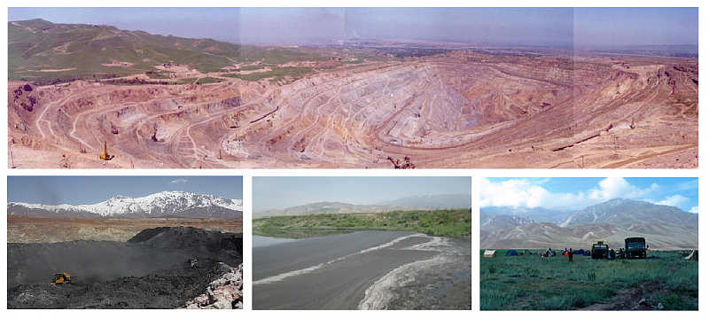
Impressions from the field work © S. Rakhmonkulova, 2017
The principal objective of this study is to assess the potential of the combined application of ground reflectance spectroscopy, geostatistics and GIS techniques for mapping, impact assessment and monitoring of metal mining related contamination. We will use different optical multispectral sensor data (ASTER, Landsat8, Sentinel 2, and WorldView2).
Contact
Prof. Dr. Cornelia Gläßer (Projektleiter),
Shakhnoza Rakhmonkulova (Projektbearbeiter)
Institut für Geowissenschaften und Geographie
Martin-Luther-Universität Halle-Wittenberg
Von-Seckendorff-Platz 4
06120 Halle (Saale)
phone: 5526020
phone: 5526025