


Use of reflectance spectroscopy and remote sensıng to predict basic soil properties in Lesser Caucasus, Azerbaijan
Use of reflectance spectroscopy and remote sensıng to predict basic soil properties in Lesser Caucasus, Azerbaijan
Funding: IWB and DAAD
Duration: 09/2016 08/2018
Project Team: Dr. Elton Mammadov, Prof. Cornelia Gläßer, Dipl.-Geogr. Michael Denk
Partners: National Academy of Sciences, Institute of Soil Science and Agrochemistry, Baku, Azerbaijan; Adam Mickiewicz University, Department of Soil Science and Remote Sensing Poznan, Poland
Project description
Motivation
Digital soil mapping (DSM) is quite evident with many significant advantages of being cost-effective, available in time and space, capable of high resolution. As a part of former Soviet Union, the largest scale, 1:100,000 national soil survey of Azerbaijan based on qualitative procedures, completed in the early 1990s after more than two decades of mapping, is gradually becoming outdated. Large-scale changes in land use, an increase in population and consequently deforestation that took place after the field surveys have had a great impact on the soil. Especially erosion of mountainous and forest soils has resulted in a substantial decline of these soils that pose a great challenge for sustainable management. Azerbaijan is among those countries where neither country scale nor regional scale DSM strategies and practice exist up to date, except key concepts. Thus, the present state of soils in national and regional scale necessitates new technological approaches, intelligent handling systems to reduce time and cost spent for soil mapping.
General scope
The general scope of the proposed research is to evaluate the feasibility of small-scale DSM employing high resolution DEM, multispectral satellite and legacy soil data. Thus, the principal aim concentrates on how to develop a small scale DSM strategies in the examples of test sites in Azerbaijan where no DSM strategies have developed up to-date.
Study area
The test sites are located in the western mountainous region of Azerbaijan, which are representatives of the Caucasus Mountain being highly appropriated for agricultural use and susceptible to soil erosion and is in need of spatial high-resolution soil maps providing a good base for decision-making.
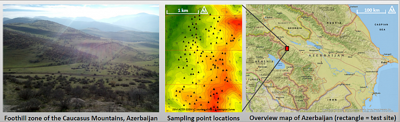
map of study area © E. Mammadov et al. 2017
Expected results
- An establishment of small-scale digital soil mapping strategies in Azerbaijan as well as key issues on country scale digital soil mapping.
- A feasibility determination of high-resolution multispectral satellite data for small-scale digital soil mapping purposes particularly in mountainous region.
- An examining of high-resolution digital elevation model plausibility, feature selection and scale issues in small-scale digital soil mapping.
- Determining availability of legacy soil map for digital soil mapping purpose.
- Progress toward prospective cooperative research projects on digital soil mapping using remotely sensed data in Azerbaijan.
Contact
Prof. Dr. Cornelia Gläßer (Projektleiter),
Dr. Elton Mammadov (Projektbearbeiter)
Institut für Geowissenschaften und Geographie
Martin-Luther-Universität Halle-Wittenberg
Von-Seckendorff-Platz 4
06120 Halle (Saale)
phone: 5526020
phone: 5526025